 Geotest - main program features
GeoTest supports multielectrode measurements along a profile line (profiling, sounding), along 2-D grids (mapping), automatic time dependent measurements (monitoring) as well as GPS position measurements. Also custom made measurements are possible.
GeoTest supports hardware manufactured by SchwaRTech (formerly LGM - Lippmann Geophysical Equipment). These are up to 255 active adressable electrodes. Using special hardware up to 65535 electrodes.
GeoTest supports data formats of many inversion program families:
- Res1D, Res2DInv and Res3DInv:
1D, 2D and 3D inversion software of M. H. Loke, Geotomo software, Malaysia
(www.geotomosoft.com) - SensInv2D and ResistivityImager2D:
2D inversion software of Thomas Fechner, Geotomographie GmbH, Germany
(www.geotomographie.de) - DC2dInvRes, DC2dTree and DC3dInvRes:
2D and 3D inversion software of Thomas Günther and Carsten Rücker, Germany
(www.resistivity.net) - AGI EarthImager:
2D and 3D inversion software of Advanced Geosciences Inc., USA
(www.agiusa.com) - ZOND
2D and 3D inversion software of Alex Kaminsky, Russia
(www.zond-geo.com/english)
More details
- profiling measurements using equidistant electrodes
- mapping measurements using regular electrode grids. X- and Y- steps can be different
- custom made electrode configurations (non conventional arrays), in profiling and mapping mode as well
- supports files with up to 45000 measurements
- support of GPS position measurements. Can be combined with Schlumberger soundings at each new position
- support of automatic monitoring measurements (time-dependent)
using up to 12 files as templates - pseudo sections or depth slices of resistivity and phase angles as well
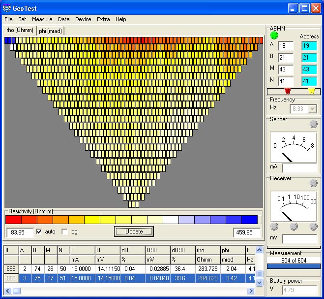
- visualisations:
active electrode numbers, sender current, sender voltage, measurement voltage, pseudosection of resistivity as well as phase angle, user selectable color bars in pseudosections, COM port status and more ... - supports many electrode configurations, including configurations with 1 or 2 remote electrodes:
- Wenner (= Wenner alpha), Wenner beta, half-Wenner, averaged half-Wenner
- dipole-dipole (dipole distances and dipole lengths can be set independently)
- Schlumberger, half-Schlumberger
- MGA = Multiple Gradient Array
- FRG = Full Range Gradient Array
- pole-pole
- pole-dipole
- square
- hybrid modes
- custom made configurations - supports borehole electrodes
- supports user selectable electrode coordinates in 3 dimensions (e.g. Gauss-Krüger and elevation),
including borehole electrodes - supports remote electrodes as infinitely far away or by using their coordinates
- exact geometric factors for remote electrodes with known coordinates
- approximized geometric factors for remote electrodes assumed to be infinitely far away - supports addressed remote electrodes
- supports optimized roll-on technique for long profiles
- supports roll-on technique for mapping measurements as well
- supports roll-back procedures
- supports frequency soundings and phase angle measurements
- supports measurements of contact resistances of each single electrode
- support various cable test procedures, e.g. for searching for the location of a broken cable connection
- various measurement settings. Presettings for:
- standard
- high quality
- disturbed measurement areas (e.g. urban environment)
- fast
- frequency soundings - supports various sorting of data
- forward or backward measurements, or both
- increasing and decreasing sorting
- sorting by measurement number, electrode number, profile position, investigation depth
- sorting by electrode number can save time using Roll-on procedure:
while the measurement is running, no more used electrodes can be disconnected and rolled on. - easy editing and re-measuring of data, even single data points
- exports various data formats:
- GeoTest generic format including all data and settings
- Res1D
- Res2DInv
- Res2DInv non conventional data format
- Res3DInv
- SensInv2D
- ResistivityImager2D
- DC2dInvRes
- DC2dTree
- DC3dInvRes
- EarthImager URF
- ZOND 2D and 3D
- general CSV text file format for resistivity data and contact resistance data
- 4-point-light parameter data format for autonomous measurements (TOM and MON modes) - import data formats:
- GeoTest generic format including all data and settings
- 4-point-light data format from autonomous measurements (TOM and MON modes) - user interface in English and German
- detailed user manual as printable PDF document, in English as well as in German.
This document is downloadable also. - user tutorial as printable PDF document available, also for download
- suggestions of customers are always welcome. Because I am the programmer of this software, there is no detour in incorporating new interesting features into the program
Computer requirements
- GeoTest runs on desktop or notebook PCs with Windows operating systems, e.g. Win 10. Geotest runs on 32 bit as well as 64 bit systems. Geotest for older windows versions is available on request.
- User must have administrator rights.
- Main hardware specifications:
Processor speed and graphics: not critical.
Recommended RAM: 512 MByte or more.
Display resolution: 1024 pixels x 768 pixels or more
Minimum disk space appr. 10 MByte - One serial interface needed (COM port = RS232 interface).
An USB-to-Serial adapter works without problems. - Two serial interfaces needed in case of using an additional GPS device.